How glorious a greeting the sun gives the mountains!
To behold this alone is worth the pains of any excursion a thousand times over.
— John Muir, The Mountains of California (1894)
The U.S. Geological Survey worked overtime when mapping the grand sweep of Yosemite National Park. With 146 named peaks (including 16 domes and numerous iconic cliffs), each has its own personality creating a mountain playground where soaring summits pierce blue Sierra skies.
From the remote and rocky crowns of the Yosemite backcountry to Yosemite Valley’s legendary massifs such as Half Dome and El Capitan, here is a who’s who of Yosemite mountain peaks and how to visit them.
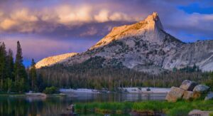
Yosemite’s Highest Peaks
The highest peaks in Yosemite are located along the Park’s eastern boundary south of Tuolumne Meadows. The drive up Tioga Road (Highway 120) boasts sweeping views and provides a profound sense of being “on top of the world.” Note: Tioga Road/Highway 120 closes seasonally due to snow (as do its campgrounds), typically late November-June. Be sure to check current road conditions before visiting.

13,114 ft (3,997 m)
Photo: National Park Service
Mount Lyell is the highest peak in Yosemite. Located 13.5 mi (21.7 km) south of Tuolumne Meadows from the Lyell Canyon Trailhead, Mount Lyell is considered a challenging ascent complete with its own glacier. But for the mountain aficionados out there who aren’t climbers, the first nine miles up Lyell Canyon are relatively flat as the trail follows the Lyell Fork of the Tuolumne River.
Fun Fact: Mount Lyell is located along the famed John Muir Trail (211 miles/339.6 km) connecting Yosemite to Mount Whitney (14,505 ft/4,421 m), the highest peak in the contiguous United States. The John Muir Trail, in turn, is part of the impressive Pacific Crest Trail (2,650 mi/4,265 km) connecting Mexico with Canada.

13,057 ft (3,980 m)
Photo: Scott Marengo
Mount Dana is the second highest mountain peak in Yosemite and located 3 miles (4.8 km) from Yosemite’s eastern Tioga Pass Entrance. At just 6 mi (9.7 km) out & back, the summit of Mount Dana is a “walk-up” (reached without technical climbing) but be prepared for the 3,100 ft elevation gain! Easy parking across from the trailhead at the Tioga Pass Entrance makes for the perfect day hike.
Pro Tip: After your day’s adventure head back to Yosemite Valley and celebrate with beer and bites.

13,002 ft (3,963 m)
Kuna Peak is the third highest mountain peak in Yosemite and located 9.4 mi (15.1 km) from the Mono/Parker Pass Trailhead along Tioga Road. Its name is derived from the Western Mono language meaning “fire” or “firewood.”

12,978 ft (3,956 m)
Located just over a mile (1.6 km) southeast of Mount Lyell, Rodgers Peak is the fourth highest mountain peak in Yosemite and straddles the boundary between Yosemite National Park and the Ansel Adams Wilderness (named after the famed Yosemite photographer).

12,880 ft (3,930 m)
Photo: Craig Barlow
Mount Maclure stands as the fifth highest mountain peak in Yosemite and is located less than a mile (1.6 km) northwest of Mount Lyell. Like its neighbor, Mount Maclure has an impressive glacier — one of only two glaciers remaining in Yosemite.
Where To Stay: For those interested in backpacking the Yosemite High Country, all overnight stays require a Wilderness Permit so be sure to plan ahead and pack the appropriate gear. For max comfort (and a hot shower!) consider the Backpackers’ Bookend before/after your adventure.
Pro Tip: Day hikers do not require a Wilderness Permit and can hop on the Yosemite Valley to Tuolumne Meadows Hikers Bus which will deliver you back to your accommodations in Yosemite Valley.
Yosemite’s Most Popular Peaks
For visitors from across the globe, Yosemite’s most popular peaks have become well known due to their distinct profiles and challenging climbs, not to mention their proximity within Yosemite Valley.

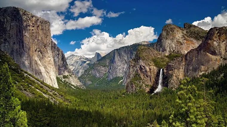
People often ask, “what’s that mountain in Yosemite everyone climbs?” The answer: El Capitan. As you enter from the west “El Cap” is the first of the celebrity rocks to greet you. This massive wall of granite rises 3,000 ft (900 m) from the valley floor and is a beacon for accomplished climbers worldwide.
With dozens of technical routes such as The Nose, Freeblast and the Dawn Wall, El Capitan is proof-positive that there are many ways up the mountain. But its verticality can be equally appreciated from flat ground. Try Tunnel View, Southside Road near Bridalveil Fall and El Capitan Meadow for prime vantage points.

The silhouette of Half Dome is instantly recognizable whether that’s from a brand logo (The North Face), the historic photos of Ansel Adams or countless social media posts. Carved by glaciers and rising 5,000 ft (1,524 m) from the Valley floor, Half Dome’s sheer northwest profile and rounded spine create unforgettable sunrise silhouettes while becoming a magnet for the golden glow of sunset at day’s end. Add some winter snow or billowing thunder clouds into the mix and the whole frame just dazzles.
For those who left their ropes and carabiners at home, Half Dome can easily be seen from the road in numerous spots at the eastern end of Yosemite Valley, or try the paved (ADA accessible) Mirror Lake Trail as it meanders up Tenaya Canyon close to Half Dome’s base.

Located just east of Bridalveil Fall and directly across the Valley from El Capitan, this multi-pronged “rock opera” of spires, cliffs and buttresses is guaranteed to impress. This is where aid climbing (using mechanical devices and equipment for upward momentum) blossomed in the 1930’s, and the techniques developed during this period would later be used to popularize big wall climbing on El Capitan and Half Dome.

Photo: Mike Ahmadi
This distinct trio of similarly-shaped rocks are located just east of El Capitan on the north side of the Valley. Angling proudly towards the sky, the uppermost “brother” is Eagle Peak, while the other two — Middle and Lower Brother — never got their own names. Apparently, mom had a favorite. Best viewing: from Southside Drive, or the Merced River just east of Cathedral Beach Picnic Area.

Standing guard across the Valley from Yosemite Falls, Sentinel Rock (often confused with Sentinel Dome along Glacier Point Road) is iconic for its sheer face and needle shape, and has been a popular subject for painters since the Park’s inception. Best viewing is from the road near Lower Yosemite Fall, or the ADA accessible Cook’s Meadow Trail.
Where To Stay: When it comes to overnight stays, there is a range of lodging in Yosemite Valley from magnificent hotels such as The Ahwahnee to campgrounds and “camping light” in the tent cabins of Curry Village. Regardless of your preference, you’ll be close to Yosemite’s most iconic peaks.
Note: Due to Yosemite Valley’s popularity, it can be challenging to secure accommodations during peak seasons and weekends. In this instance be sure to check out the many lodging options in Yosemite’s gateway towns such as Mariposa, Fish Camp and El Portal/Midpines. Here you’ll find friendly locals, a variety of restaurants and year-round attractions such as museums, shopping and health spas.
Elevated Extras
- For a detailed look at Yosemite’s famous rock climbing history visit the Yosemite Climbing Museum in the town of Mariposa (and grab a bite to eat).
- If rock climbing intrigues you but you don’t know where to start, try the Yosemite Mountaineering School & Guide Service where pro climbers quite literally teach you the ropes.
- Science-minded visitors will enjoy learning about Yosemite’s epic geology. Uplifting, indeed.
- Grab a seat on the year-round Yosemite Valley Floor Tour where your guide shares the Park’s story from a geological, historical and cultural perspective.
- Mountain peaks may seem invincible, but our wild lands are more fragile than they appear. Consider volunteering in the Park and its gateway communities for such events as the Yosemite Facelift (sponsored by the Yosemite Climbing Association).
- March 08, 2025Celebrate Earth Day in YosemiteEvery April, nature lovers and conservationists come together to celebrate Earth Day, a global movement dedicated to protecting our planet. In Yosemite Mariposa County, where towering granite cliffs, rushing waterfalls, […]Read More

- March 07, 2025Celebrated Summits: The Mountain Peaks of YosemiteHow glorious a greeting the sun gives the mountains!To behold this alone is worth the pains of any excursion a thousand times over.— John Muir, The Mountains of California (1894) […]Read More
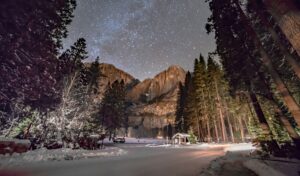
- October 23, 2024The Coolest View: Winter Stargazing in Yosemite MariposaYosemite Mariposa boasts one particular activity that literally outshines the rest: winter stargazing.Read More